
This post is a look back at when I did a solo backpacking hike to Davis Pond in Baxter State Park in September of 2014. It’s one of the more remote and private hikes in the park, requiring an overnight at Russell Pond the night before you go to Davis. Reservations for Davis Pond lean-to often book months in advance, but if you are lucky enough to make a reservation, it’s a unique and memorable backpacking trip to the backside of Mount Katahdin.

Hike Details
- Distance: 20 miles
- Elevation Gain: 5000 ft
- Route Type: Loop
- Duration: 3 days
Day 1: Roaring Brook to Russell Pond
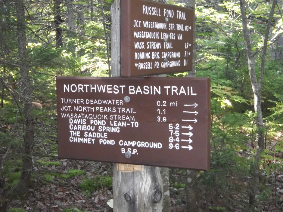
I drove to Roaring Brook Campground early in the morning to park my car for the 7.5-mile hike to Russell Pond. The trail is mostly through woods and features a couple of river crossings. One of the river crossings over Wassataquoik Stream necessitated stripping down to my underwear and carrying by belongings above my head, as it was nearly waist deep. Luckily, I didn’t slip on the slick rocks while crossing the stream barefoot. I had brought a pair of sandals for better footing.


Day 2: Hiking to Davis Pond
That night was pretty frigid, with temperatures in 30’s. Although there was abundant sunshine the next morning, it didn’t feel much warmer, so I started my day in a winter hat and fleece. Davis Pond lean-to would only be a 5.2 mile hike, but would be more elevation change than the previous day. The hike crossed the stream a few more times and went up some steep rock slides. It was a beautiful day for a hike, and the area above Davis Pond was a wonderful place to relax in the sun. Other than a couple of rangers who were passing through the campground, I had that side of the mountain to myself. The outhouse was particularly memorable, with a sign marking the “New Thunder God’s Throne”. Not sure of the backstory of that one.
Davis Pond is very similar to Chimney Pond in that it’s a pond at the bottom of a basin carved out by glaciers thousands of years ago. It’s located at nearly 3000′ above sea level.


Day 3: Hiking Katahdin and Back to my Car
The night was extremely windy and the noise of the wind kept me up for much of the night. I remember being a tad nervous about bear visitors since it was close to hibernation season and the bears were getting ready for their winter slumber. Since I was already awake, I got to watch the dawn light arrive at the basin as I warmed up a delicious breakfast skillet.
The hike up the backside of Katahdin was very steep and wooded for the most part. Once I arrived above the trees on the plateau of Katahdin, I was greeted with very strong gusts of wind and clouds that blocked much of a view. I remember my fingers being cold despite having gloves, and found it difficult to push against the wind.


I hiked 2.1 miles to Hamlin Peak, didn’t have a view, so I pushed on down the Hamlin Ridge trail. As I descended the trail, the clouds started to lift and I was greeted with sunshine and views. There were a large number of hikers that were going up the trail who looked at me with amazement that I had a large pack on Katahdin.
On the way down, I looked at large fields of blueberry plants and found a family of bears eating their breakfast. Luckily I was far enough away that I didn’t feel like I was in danger, but it was amazing to see black bears feeding in the open since they are usually so skiddish.


I eventually made it back down to Roaring Brook campground after hiking for an additional 3.5 miles and felt a huge sense of accomplishment as I completed my first multi-day solo backpacking trip.
The Davis Pond trip is highly recommended for anybody who want to have some adventure off the beaten path. It wasn’t the longest hike I’ve done, but it was a challenge to go up and over Katahdin with a heavy backpack.